Month: January 2025
THE DIRT: Air quality monitoring
Your family sledding trip should only leave your calves burning. But you feel it more in your chest after a smoky day in our narrow Silver Valley. Think back to the red AQI forecast on your phone. What information was it trying to convey? The Air Quality Index (AQI) is a color-coded tool to relay air pollution threats. Starting at GREEN, for good, colors warm to MAROON, for hazardous. The AQI can represent a variety of pollutants. In North Idaho, two air pollutants are monitored—PM10 and PM2.5.
The air around us contains particulate matter (PM). This term describes the microscopic solids and liquid droplets suspended in the atmosphere. These inhalable drifters can be pollen, dust, or other harmful particles. PM10 is the subgroup of these particles smaller than 10 micrometers (µm). About the size of one-tenth a grain of salt, PM10 particles can often be coughed out. PM2.5, on the other hand are tiny, 2.5µm in size. Measuring about one-20th of a strand of hair, these particles can be breathed in so deeply that they cannot be expelled. They can build up with each exposure and lead to the most risks. Associated toxins can pass directly into the bloodstream causing adverse effects.
This year, the EPA lowered the annual PM2.5 standard to reflect a better understanding of health risks associated with long-term exposures. This is one of the National Ambient Air Quality Standard (NAAQS) criteria pollutants that is monitored to help protect environmental and community health. The current primary standard for annual PM2.5 is 9.0 micrograms per cubic meter (µg/m3). This concentration of particles in the air is considered safe for most people. It corresponds with the maximum of the GREEN category from the AQI. When the average concentration rises above 9.0µg/m3 for 24 hours, there is an increased risk of short-term effects. Furthermore, when the annual average has excess days above the GREEN category, you start to see the riskier long-term effects associated with exposure to PM.
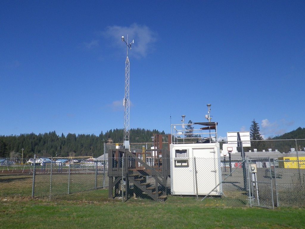
To help the community make informed choices and monitor potential health risks, a monitoring site in the Silver Valley was installed near Pinehurst Elementary School. The site features weather data collection, monitors for collecting PM2.5 and PM10 data and a NASA robot that monitors the upper atmosphere. Keeping tabs on this data with the DEQ Air Map and watching for AQI forecasting is easy! It can help you make informed decisions on how much time you and your family should be spending outdoors. Paying attention is just the beginning of protecting ourselves from poor air quality.
The Dirt is a series of informative articles focused on all aspects of cleanup efforts associated with the Bunker Hill Superfund Site. Our goal is to promote community awareness of contamination issues, to provide tools for protecting public health, and to keep the community informed of current and future cleanup projects. The Dirt is a group of committed and local experts from multiple agencies including the Basin Environmental Improvement Project Commission, Panhandle Health District, Shoshone County, Silver Valley Economic Development Corporation, and the Idaho Department of Environmental Quality.
THE DIRT: Understanding the work throughout Burke Pt. 2

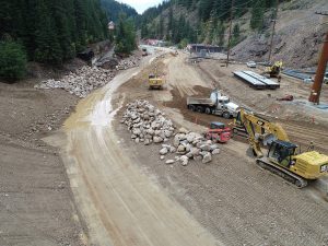
The cleanup at the Hecla Star Complex started in 2023. The area known as Burke saw a big increase in construction work this past summer and will continue through the summer of 2026. Notably, the biggest change this summer was the installation of a very large box culvert that was placed near the large concrete mill building. Great efforts were taken to avoid impacts to the large historic buildings along Burke Road and to salvage the concrete stamped “HECLA 1923” at the culvert outfall. The creek was diverted during installation but was reintroduced into the culvert and stream channel at the end of 2024. The culvert was installed to reduce area flooding and is robust enough to handle a 100-year storm event. This will not only reduce flooding downstream but also reduce the possibility of recontamination from transported mining waste into the floodplain.
Work will continue near Burke next season. The emphasis will be on removing contaminated waste from Burke Road’s roadbed and the Canyon Creek corridor. Mine waste was commonly used as the foundation for the area roadways, and that waste is over 20 feet deep in some areas. The asphalt on Burke Road is rapidly degrading, exposing contaminated materials and creating a danger to public health. To remove these contaminated materials, Burke Road will need to be reduced to one-lane traffic, while each side is excavated out, backfilled with a new clean road base, and re-paved following project completion in 2026. In addition, cleanup work will remove contamination from the Canyon Creek stream corridor and a natural stream channel will be rebuilt upstream from the Star complex, up to Gorge Gulch. These extensive efforts will not only improve surface water quality but will provide a freshly paved section of road for travelers to the area. The work is expected to be completed in the Hecla Star area in the fall of 2026.
Once the Hecla Star Complex project is completed, work will continue downstream on additional sites. Historically, there were many different mill sites in the canyon. Crews will begin working to address the areas that impact human health and recreation the most. The current plan is for work to begin at the Tamarack No. 7 in 2025, the Flynn/Black Bear in 2026 and the Standard Mammoth in 2027. The work is anticipated to have less impact to traffic on Burke Road; however, an increase in truck traffic as part of the removal and replacement actions taking place should be expected.
Cleanup work may be an inconvenience for those who live and frequent this area, but good things come to those who wait. Once work is complete, the area will be cleaner, and the risk of metals exposure to humans and wildlife will be greatly reduced.
The Dirt is a series of informative articles focused on all aspects of cleanup efforts associated with the Bunker Hill Superfund Site. Our goal is to promote community awareness of contamination issues, to provide tools for protecting public health, and to keep the community informed of current and future cleanup projects. The Dirt is a group of committed and local experts from multiple agencies including the Basin Environmental Improvement Project Commission, Panhandle Health District, Shoshone County, Silver Valley Economic Development Corporation, and the Idaho Department of Environmental Quality.
THE DIRT: The History of the Cataldo Dredge

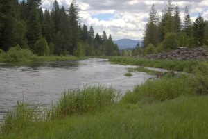
One of the most scenic views along Interstate 90 in the Silver Valley is arguably found when driving west across the Mission Flats area of Cataldo. As the trees break away, you encounter the beautiful site of Latour Baldy and Silver Mountain in the background, with the historic Cataldo Mission in the foreground surrounded by serene swamps and wetlands. This area may look beautiful today, but it was not always so. In fact, historically this area was used for the consolidation of massive amounts of mine wastes traveling downstream from the many mines and mills of the Upper Basin.
Historically, hard rock mining in the Silver Valley region used disposal methods that were common across the nation. Flowing creeks and streams provided an easy disposal mechanism for industrial waste. In the Silver Valley, those wastes were primarily mine and mill tailings, and slimes. While not the original intention of mine operators, these practices harmed the environment, the ecosystem, and human health.
By the early 1900s agricultural areas, especially along the lower sections of the Coeur d’Alene River, became inundated with these waste products. Farmers watched helplessly as their crops died and their livestock became poisoned, leading to dozens of farmers filing lawsuits against the mining companies. The mines were given preferential treatment in these court rulings, but due to court costs and settlement fines, the Mine Owners Association (MOA), an organization comprised of thirteen local mining companies, began efforts to curtail the amount of mine waste migrating downstream. Early efforts included the construction of a series of plank dams that the MOA hoped would slow the migration of the waste. Dams were constructed on Canyon Creek at Woodland Park and on the South Fork of the Coeur d’Alene River (SFCDA) at Osburn and Pinehurst. While the dams reduced the volume of suspended solids carried downstream, they could not contain the finer tailings generated by the new flotation method being implemented across the Coeur d’Alene mining district. The dams were also easily damaged and breached during high water and flood events. Without proper maintenance and constant re-building, they stopped functioning.
From late 1929 to early 1930, Coeur d’Alene Press editor John Knox Coe ran a series highlighting the pollution problems of the Coeur d’Alene Basin. Coe’s series helped spotlight this issue and put pressure on local officials to take these concerns to the capital. In response, the Idaho state legislature created the Coeur d’Alene River and Lake Commission. A 1932 study led by Dr. M.M. Ellis of the United States Bureau of Fisheries found no live fish species in the main Coeur d’Alene River nor in the SFCDA up to Mullan. After his months-long study, Dr. Ellis concluded that “there is but one solution for this pollution problem as far as fisheries are concerned, namely, the exclusion of all mine wastes from the Coeur d’Alene River.”
Prior to the Ellis study, the MOA had consulted with the U.S. Bureau of Mines to develop a new plan for addressing mine waste in the Coeur d’Alene River system. The group decided to construct a large floating suction dredge below the Cataldo Mission on the main channel of the Coeur d’Alene River. The MOA established a Dredge Fund and over twenty-three mining companies contributed to the fund. W.L. Zeigler, a local mine engineer, was selected to design the dredge and develop an operating plan. More than two thousand acres of Mission Flats were purchased to be used as the impoundment area for the dredge. The MOA determined that this location was ideal because this portion of Mission Flats, where the river converted from a high to a low gradient system, already acted as a natural deposition zone. Mine waste naturally settled out across the flats and at times the river flowed so slowly along this stretch that build-up would partially plug the river channel, making boat travel difficult or impossible. When Dr. Ellis assessed this new dredging method, he concluded that the operation of the suction dredge would reduce the amount of waste carried downstream, but could not capture and contain the finer particles, nor would it impact the upriver pollution. He warned that “this pumping out of mine slimes will be helpful to some extent but it will not solve the pollution problems in the Coeur d’Alene River.” But investments had already been made, and despite Ellis’ criticisms, the MOA continued with their operational plans.
This dredge differed from the traditional ladder dredges used in the Murray gold fields just north of the Silver Valley. It operated by collecting tailings scoured from the river bottom through a powerful pump. It then transported the tailings through a large flexible rubber pipe floating on steel drum pontoons that would connect to one of four heavy discharge stations spaced along the shore. The floating line would then connect to each discharge station as the dredge moved down the pond. Once transported to the discharge stations, the tailings were then carried from the water’s edge up to the top of the impounding dike out into the impound area. The pumped water would then travel through a series of ponds and sloughs, that provided a way for the remaining tailings to settle out before returning to the river. Powered by electricity from a nearby substation, the dredge could pump approximately 7,000 gallons of water per minute, removing an estimated five hundred tons of sediment per hour. The dredge operated 22.5 hours per day, after springtime high waters receded, through the summer months into the fall until the onset of freezing temperatures which could cause mechanical disruptions. From 1932 to 1968, it removed an estimated 34.5 million tons of tailings, which were deposited across more than two thousand acres of Mission Flats at depths of thirty-five to forty feet in places. In the late 1950s and early 1960s, the Idaho Department of Highways contracted with the MOA to direct approximately one million tons of tailings between two parallel dikes, constructing the roadbed for Interstate 90 through Mission Flats, which we still drive across today.
For over eighty years, Silver Valley mining companies legally discharged waste products without limits or safeguards. In 1968, state and federal regulations mandated that mine and mill operators completely cease direct discharges and begin impounding all tailings on company-owned property. With the construction of individual tailings impoundment ponds, there was no longer a need for the dredge. It was dismantled, scrapped for parts, and the rest abandoned in place. While the dredge ended operations more than 55 years ago, the mine tailings impounded on Mission Flats remain today. Most of these dredge tailings have the look and consistency of fine beach sand and still contain dangerous levels of heavy metals. Due to their very fine size, they are extremely mobile, making them easy to accidentally inhale and ingest. In the early 2000s, access controls and no trespassing signs were installed to keep the public out of the dredge area; however, tailings can still be found lining the banks of the South Fork and the main Coeur d’Alene River. It is advised to avoid contact with sediments along the river and for recreators to use recommended guidance to protect your and your family’s health when recreating in these areas. For more information please visit www.deq.idaho.gov/waste-management-and-remediation/mining-in-idaho/play-clean-in-the-coeur-dalene-basin/.
The Dirt is a series of informative articles focused on all aspects of cleanup efforts associated with the Bunker Hill Superfund Site. Our goal is to promote community awareness of contamination issues, to provide tools for protecting public health, and to keep the community informed of current and future cleanup projects. The Dirt is a group of committed and local experts from multiple agencies including the Basin Environmental Improvement Project Commission, Panhandle Health District, Shoshone County, Silver Valley Economic Development Corporation, and the Idaho Department of Environmental Quality.
Related Articles