While flooding in North Idaho is not uncommon, high flow events like the one that occurred in December 2025 can have consequences that extend beyond immediate water damage. When high flows sweep through the Coeur d’Alene River Basin, they interact with a landscape shaped by more than a century of mining activity. Historic discharges mean that floodwaters have the potential to move metals and other pollutants downstream, affecting both the environment and the communities that live along these waterways.
Flood damage usually brings to mind washed-out roads, detours, and debris—but when floods hit contaminated waterways like those in the Coeur d’Alene River Basin, the risks go far beyond the obvious. From 1884 until 1968, Silver Valley mines directly discharged millions of tons of metals contaminated mine waste into the South Fork of the Coeur d’Alene River and its tributaries. These wastes traveled downstream into the main channel of the Coeur d’Alene River and chain lakes of the Lower Basin, leaving a devastated landscape behind. The waters of the South Fork and main stem of the Coeur d’Alene River ran milky gray, the vegetation lining the banks died off, and wildlife abandoned the area. The magnitude and duration of historic practices left a vast legacy of contaminated sediment throughout the river corridor and its connected aquatic and floodplain habitats.
The increased volume and speed of water traveling downstream during flood events can greatly disturb these historic sediments, dislodging them from the riverbed and banks, carrying them downstream and into the nearby low-lying lands. As weather conditions improve, floodwaters begin to recede, and the process of deposition begins. Deposition is a normal process that occurs as floodwaters lose their velocity and begin to subside. The sediments begin to settle out and remain on the surface of the land after the waters return to normal levels in the river. When this occurs within contaminated areas, contaminated sediments can be left behind.
As the years passed with no direct discharges of mine waste to the river and remediation began throughout the Coeur d’Alene River Basin, the land showed signs of recovery. The waters of the Coeur d’Alene River no longer ran milky gray with mine waste, the floodplain became revegetated, and wildlife began returning to the area. River and lake front properties in the Lower Basin no longer looked polluted and people began to view the land as prime recreational real estate. Unfortunately, these properties are still contaminated, and continue to pose a risk to human health, wildlife, and the environment.
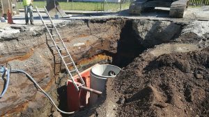
When properties along the river and portions of the chain lakes are developed for recreational or residential use, owners are required under Panhandle Health District’s Institutional Controls Program to install clean barriers anywhere contaminated land is being developed, actively used, and/or maintained. Clean surfaces such as gravel, topsoil, asphalt, or concrete, when installed properly, help protect those using the land from exposure to metals such as lead, arsenic, and cadmium, and these clean barriers have been proven to reduce exposure to these metals. However, when floodwaters inundate remediated areas, barriers can be compromised in several ways: gravel may erode or become mixed with contaminated sediments, concrete or asphalt can crack or heave, and vegetated or “greened” areas can be buried under a thin layer of contaminated silt that is not always visible at the surface. Over time, these conditions can reduce the effectiveness of the barrier. It is the property owner’s responsibility to protect and maintain their barriers, which can be a costly expense.
Flooding can undo years of remediation, leaving contaminated sediments on properties and compromising protective barriers. Property owners along the Coeur d’Alene River and chain lakes should inspect and maintain clean surfaces after every flood and contact the Panhandle Health District (PHD) for guidance to keep their land safe from lead, arsenic, and cadmium exposure.
The Dirt is a series of informative articles focused on all aspects of cleanup efforts associated with the Bunker Hill Superfund Site. Our goal is to promote community awareness of contamination issues, to provide tools for protecting public health, and to keep the community informed of current and future cleanup projects. The Dirt is a group of committed and local experts from multiple agencies including the Basin Environmental Improvement Project Commission, Panhandle Health District, Shoshone County, Silver Valley Economic Development Corporation, and the Idaho Department of Environmental Quality.

 Official Government Website