
Month: April 2026
THE DIRT: From Flood to Drought: Why North Idaho Is Still Short on Water
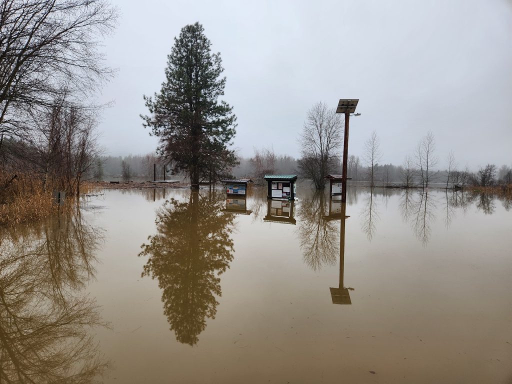
To many people, December’s flooding may have looked like the end of North Idaho’s drought. In reality, the region’s water picture remains fragile—and in some ways, the flood masked deeper problems.
North Idaho has experienced some level of drought since the summer of 2021. While only water year 2024 saw well-below-normal snowpack overall, most recent years have been marked by earlier-than-normal spring runoff and melt-out. That early melt can leave the region dry by mid- to late summer if rainfall doesn’t keep pace.
In mid-December 2025, drought designations across the Idaho Panhandle were temporarily reduced. Above-normal precipitation gave the appearance that drought conditions were easing. However, that improvement was short-lived and largely driven by rain rather than snow.
The December flood itself did little to solve the long-term water deficit. Record warm temperatures and widespread rain across all elevations meant precipitation fell as rain rather than snow. Instead of being stored in the mountains, much of that water ran quickly into rivers and downstream—eventually heading out to the ocean. The warmth also created a denser-than-normal snowpack, which is less able to absorb rainfall and more prone to rapid melt.
Despite all the water on the landscape in December, North Idaho has now slipped back into drought largely because of one missing ingredient: snowpack. Snow plays a critical role in the region’s water supply. Roughly 60 percent of North Idaho’s water comes from snowmelt. Snow acts as a slow-release reservoir, feeding rivers, lakes, and groundwater through spring and summer—when demand is highest.
One way to think about snowpack is as a savings account for seasonal workers. Winter is when you build your savings. Summer is when you live off it. If you don’t put enough away during the winter, it doesn’t matter how much money briefly passed through your hands—you’re still going to struggle later. December’s flooding was like a big paycheck that immediately went out the door, not money set aside for the months ahead.
There are some short-term benefits. Heavy rain increased soil moisture and shallow groundwater, which can improve runoff efficiency during spring melt. But without adequate snow in the mountains, that benefit is limited.
As of now, total precipitation (rain and snow combined) in North Idaho is near to slightly above normal; however, much of that moisture has fallen as rain rather than snow. As a result, snowpack—the region’s primary natural reservoir—remains below normal and has continued a concerning trend of reduced accumulation over recent winters, limiting water storage heading into the warmer months.
Climate trends suggest these rapid swings—from drought to flood and back again—may become more common. Warmer air holds more moisture, increasing the likelihood of extreme precipitation events, rain-on-snow flooding, and longer dry periods between them.
In short, December’s flood didn’t refill North Idaho’s water bank. Despite a wet winter on paper, the region enters the warmer months with below-normal snowpack, reduced natural storage, and below-normal streamflow forecasts.
The Dirt is a series of informative articles focused on all aspects of cleanup efforts associated with the Bunker Hill Superfund Site. Our goal is to promote community awareness of contamination issues, to provide tools for protecting public health, and to keep the community informed of current and future cleanup projects. The Dirt is a group of committed and local experts from multiple agencies including the Basin Environmental Improvement Project Commission, Panhandle Health District, Shoshone County, Silver Valley Economic Development Corporation, and the Idaho Department of Environmental Quality.
THE DIRT: Dayrock Mitigation
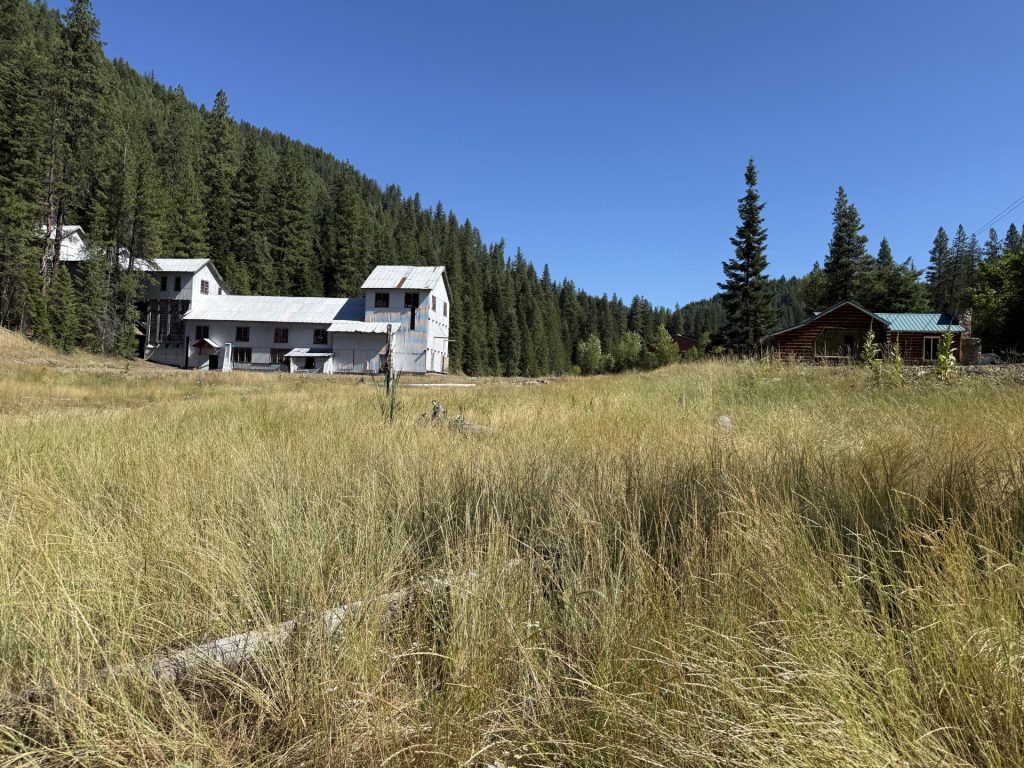
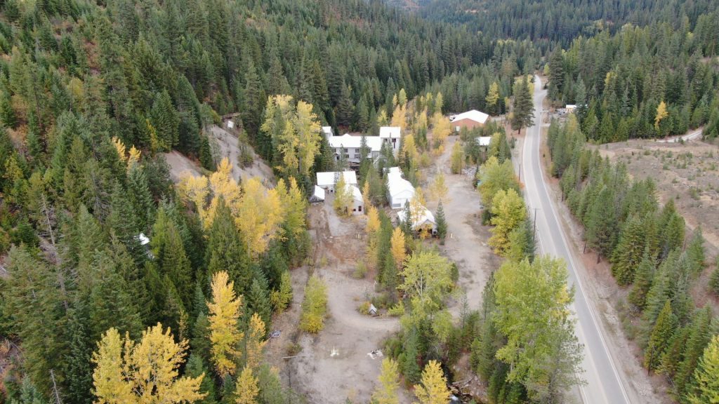
The Dayrock Complex is located near Wallace within Ninemile Creek Basin watershed and is included in the Upper Basin of the Bunker Hill Mining and Metallurgical Superfund site. This site offers a real-world example of how the National Historic Preservation Act (NHPA) guides decisions and mitigation when cleanup efforts affect historic resources. During the Historic Resource Survey, 18 historic-period architectural resources and one archaeological resource were identified leading to the determination that it is a historic district. The Dayrock Complex was determined eligible for listing in the National Register of Historic Places as a significant representation of historic mining technology.
The cleanup at the Dayrock Complex required removing several old buildings and structures that were part of its historic mining district. The work also included adding new modern features—like reconstructed creek channels and culverts which would change the area’s historic layout, setting, and materials. Because these changes affected nearly all the elements that made the Dayrock Complex historically significant, they were considered an adverse effect under the NHPA and Environmental Protection Agency (EPA) determined that mitigation was necessary, and the Idaho State Historic Preservation Officer (SHPO) concurred.
Once mitigation is determined, EPA may reach out to potentially interested parties to discuss the project, its impacts, and begin discussing options to offset the impacts of the cleanup. Since the historic resource being adversely affected is a local resource, the local community should have a voice in what comes from the mitigation process.
To address the Dayrock Complex’s adverse effects, EPA met with Idaho SHPO and several local groups—including the Wallace Planning and Zoning Department, Nine Mile Cemetery Association, Wallace Mining Museum, Wallace Chamber of Commerce, Shoshone County, and the Advisory Council on Historic Preservation—to discuss the project and gather ideas for mitigation. Based on this input, EPA agreed to turn an existing Idaho mining history study into a Multiple Property Documentation (MPD) form, which provides a common framework for evaluating similar mining sites. This MPD provides contexts for the identification, evaluation, registration, and treatment of metal ore mining properties in the geographic area of the state of Idaho during the period 1860–1977. It provides a comprehensive historical overview of mining activities and related technology. The MPD is intended to assist cultural resources professionals, landowners, land managers, and the public in identifying and evaluating mining-related properties based on eligibility criteria for listing in the National Register of Historic Places (NRHP). As part of this effort, EPA also nominated two historic properties—the Nine Mile Cemetery and the Shoshone County Poor Farm—for listing in the NRHP, helping recognize and preserve important mining-related heritage while making future listings easier and more consistent.
Selecting off-site mitigation properties, such as the Nine Mile Cemetery and the Shoshone County Poor Farm, for listing on the National Register of Historic Places offers several key benefits. Listing formally recognizes the historical, architectural, or cultural significance of these properties, providing a clear framework for preservation and ensuring their value is considered in planning decisions. It can also make the properties eligible for preservation incentives such as grants or tax credits, supporting long-term maintenance and protection. Additionally, National Register status strengthens the credibility and transparency of mitigation efforts, demonstrating a commitment to safeguarding heritage resources while achieving environmental or development goals.
By integrating NHPA requirements into Superfund cleanups, agencies ensure that environmental remediation does not come at the cost of cultural heritage. Through careful planning, consultation, and thoughtful mitigation, it is possible to protect human health, the environment, and the stories embedded in historic landscapes.
The Dirt is a series of informative articles focused on all aspects of cleanup efforts associated with the Bunker Hill Superfund Site. Our goal is to promote community awareness of contamination issues, to provide tools for protecting public health, and to keep the community informed of current and future cleanup projects. The Dirt is a group of committed and local experts from multiple agencies including the Basin Environmental Improvement Project Commission, Panhandle Health District, Shoshone County, Silver Valley Economic Development Corporation, and the Idaho Department of Environmental Quality.
THE DIRT: The National Historic Preservation Act
The Silver Valley has a rich history dominated by silver, lead, and zinc mining, which began in the late 1870s and established the region as the world’s largest silver producer by the early 1900s. Visitors come to explore this past, touring local museums to learn about mining practices as well as visit old mining structures that are peppered throughout the region. People are drawn to history because it not only reveals where we’ve been but also helps us better understand the world we live in today.
As a nation, we collectively value historic places, a belief that led to the enactment of the National Historic Preservation Act (NHPA) in 1966. Created to ensure that future generations can appreciate and enjoy the country’s rich heritage, the NHPA established a framework for recognizing historic places at risk of being lost or altered. It provides a systematic process for identifying, evaluating, and protecting historic resources, and it requires federal agencies to consider how their actions may affect historic properties, helping safeguard the nation’s cultural legacy.
To ensure that cleanup efforts do not unintentionally damage irreplaceable historic resources, federal agencies must comply with Section 106 of the NHPA. The U.S. Environmental Protection Agency (EPA) takes into account the effects on historical properties and allows the Advisory Council on Historic Preservation (ACHP) to comment on the work planned. EPA is responsible for identifying any historic properties that may be affected, assess the potential impacts, and consider ways to avoid, minimize, or mitigate any adverse effects. They also consult with the State Historic Preservation Officer (SHPO) and/or Tribal Historic Preservation Officer (THPO) to understand the characteristics of the property that make it historic. Early and ongoing consultation is a cornerstone of the Section 106 process and can uncover information about historic properties or archaeological features that might not be documented elsewhere. This process ensures that environmental remediation and historic preservation move forward together.
Once it is determined a project may affect a historic property, a Historic Property Management Plan (HPMP) may need to be developed. HPMPs were developed for the Upper and Lower Basins of the Bunker Hill Superfund Site to outline the process that EPA will implement to achieve the substantive requirements of the NHPA for ongoing and future cleanup efforts. The HPMPs provide information related to the environmental and cultural context of the area, known and anticipated conditions, and overviews of actions and potential effects that may occur during cleanup activities. The HPMPs also provide project-specific procedures, such as pre-construction cultural resource surveys, that should be completed prior to initiating cleanup work.
As EPA determines how they plan to remediate each site, they work with SHPO, THPO, and other consulting parties to apply the “avoid, minimize, or mitigate” framework required under Section 106. Because much of the cleanup in the Silver Valley requires full removal within the watershed, EPA continues to coordinate with the ACHP, SHPO, and THPO. If adverse effects to historic properties cannot be avoided or minimized, mitigation is required and a mitigation plan must be developed. In which case, impacts are addressed by collecting important archaeological information, creating records and photos of the site, sharing its story through signs or displays, or protecting similar historic places elsewhere.
The Dirt is a series of informative articles focused on all aspects of cleanup efforts associated with the Bunker Hill Superfund Site. Our goal is to promote community awareness of contamination issues, to provide tools for protecting public health, and to keep the community informed of current and future cleanup projects. The Dirt is a group of committed and local experts from multiple agencies including the Basin Environmental Improvement Project Commission, Panhandle Health District, Shoshone County, Silver Valley Economic Development Corporation, and the Idaho Department of Environmental Quality.