Author: Emily Hasz
THE DIRT: Restoration work at historic Pine Creek mine sites
Abandoned mines and millsites throughout the Silver Valley are cherished by locals and visitors alike for their historic significance. These sites offer a glimpse into what daily life looked like for the hard-working men and women who ran these operations and developed the mining industry that shaped our local communities. As mentioned in part one of this series, the mines of Pine Creek, with their relatively short life spans, did not produce record-breaking amounts of ore, but they still have a vibrant and storied past that is full of interesting local history.
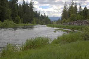
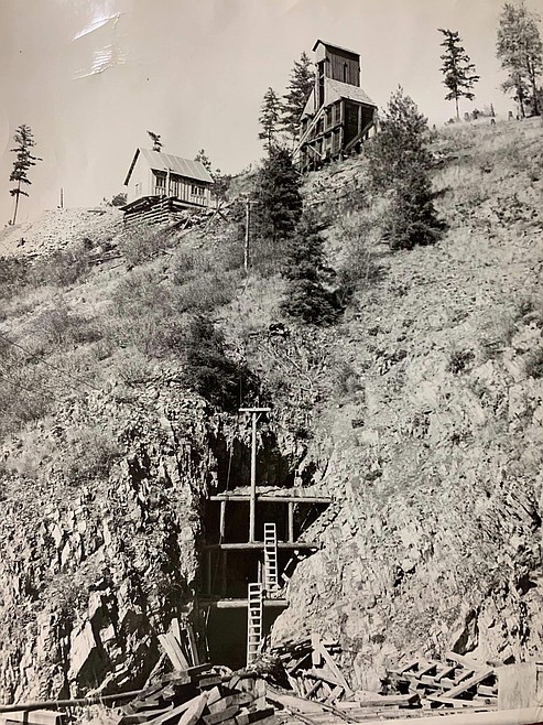
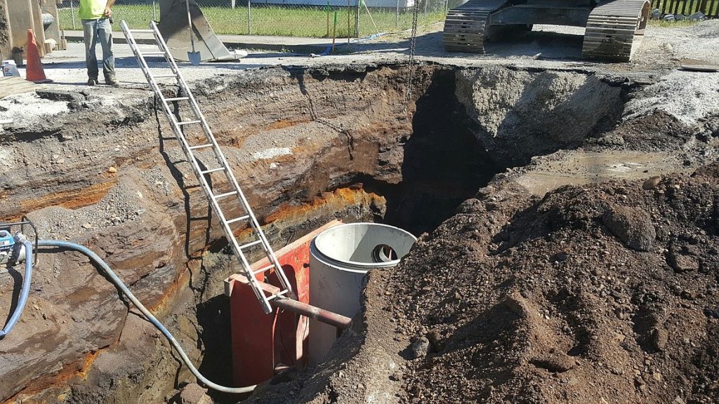
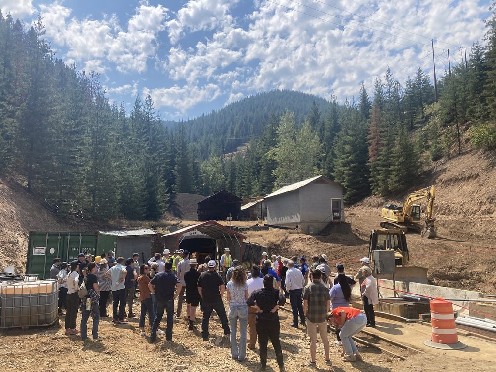
The Douglas Mine and Millsite is one of the more publicly visible sites within the Pine Creek District. It is located 6.4 miles south of Pinehurst, on the East Fork of Pine Creek, just north of the mouth of Douglas Creek. Ore was first discovered at the site in 1898, and by 1913, the Douglas Mining Company had patented ten claims comprising 144 acres. The Douglas Mine grappled with the same challenges that other Pine Creek mines faced with their zinc rich ore, which proved difficult to separate from the lead minerals. In 1924, the Douglas site fell victim to a devastating forest fire that destroyed surface operations, including cabins, supplies, and mining equipment. Though the company rebuilt within a year, in 1928, a forest fire once again leveled the mine’s surface workings. Not knowing that the Great Depression loomed, the mine rebuilt yet again, this time with a new hoist house, compressor building, timber shed, blacksmith shop, store, and several dwellings. As the Depression set in, metal prices dropped, causing the mine to cease operations in 1930. In 1943, mining commenced again when the company leased operations to the Small Leasing Company who built a new 100-ton flotation mill at the mine. Production surged during the Korean War but steadily declined afterward until the mine’s official closure in 1972.
While the Douglas Mine and mill site has sat vacant of its grand timbered buildings for decades, it still housed dangerous remnants of its past. Historic mining operations contaminated soils across the site with hazardous levels of metals, including lead, arsenic, and zinc, creating human health and environmental hazards. Vegetation struggled to grow in these contaminated materials, leaving a flat, open expanse that became popular for activities such as dirt biking, ATV riding, camping, and target shooting. These activities put people into direct contact with contaminated materials, creating human health and environmental hazards. As cleanup measures associated with the Bunker Hill Superfund Site wind down in residential areas, the Coeur d’Alene Trust is now addressing these kinds of mine and mill sites located in the more remote areas of the Silver Valley.
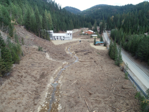
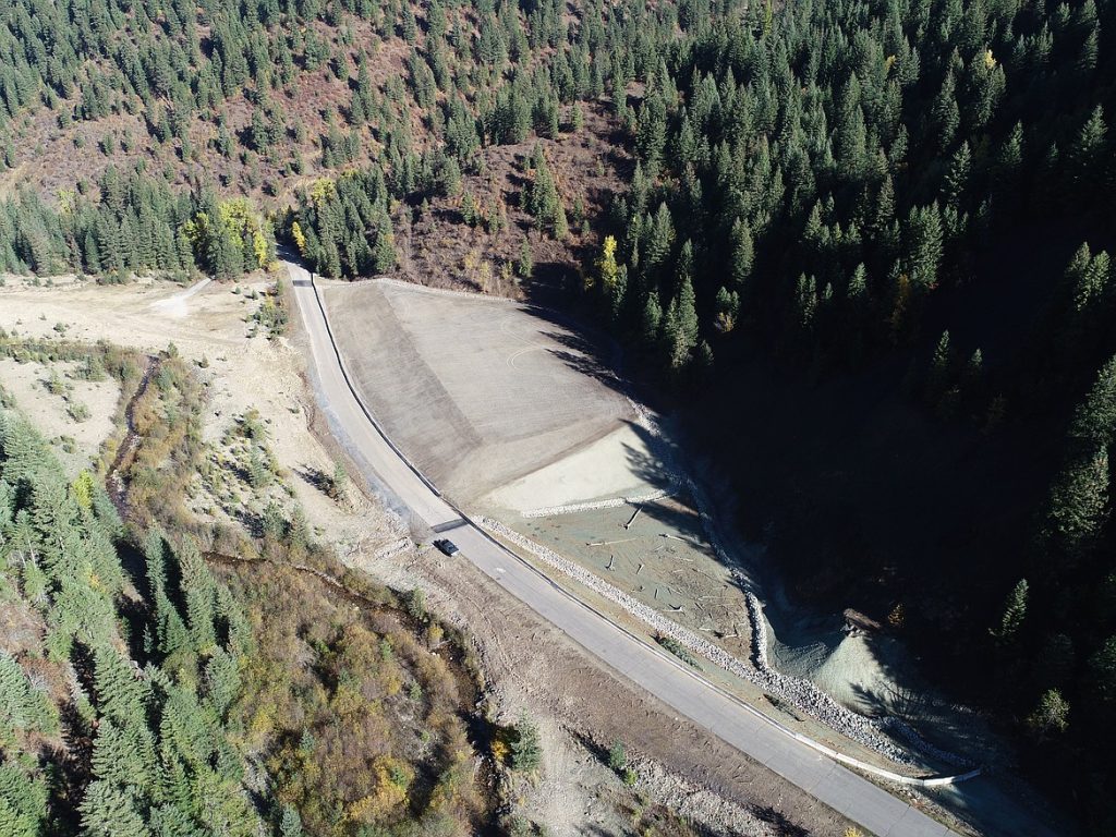
Sampling and the development of a site cleanup plan for the Douglas began in 2019. Cleanup activities kicked off in the spring of 2025 and wrapped up this fall. Approximately 26,000 cubic yards of mine waste were excavated from around the area and consolidated on site. This waste was then covered with a 14,700 square yard liner system, which was capped with three feet of clean cover materials. In addition, crews constructed 1,800 linear feet of storm water channel, installed two 24” culverts to convey storm water from the site, and built an adit conveyance system to capture seasonal flows from the adit. In total, approximately 14,100 cubic yards of clean backfill were installed across the site, and access controls were placed around the perimeter to protect the final remedy. Cleanup activities help transform sites so they no longer pose risks to human health or the environment. This work represents meaningful progress for the Silver Valley, and our community can proudly recognize the efforts being made to improve human health and the environment, which makes it a safer place for all to enjoy.
The Dirt is a series of informative articles focused on all aspects of cleanup efforts associated with the Bunker Hill Superfund Site. Our goal is to promote community awareness of contamination issues, to provide tools for protecting public health, and to keep the community informed of current and future cleanup projects. The Dirt is a group of committed and local experts from multiple agencies, including the Basin Environmental Improvement Project Commission, Panhandle Health District, Shoshone County, Silver Valley Economic Development Corporation, and the Idaho Department of Environmental Quality.
THE DIRT: History of mining in Pine Creek
While not as notable as Bunker Hill, Sunshine, or the Hecla Star, the mines of Pine Creek cannot go without proper recognition for their contributions to the Silver Valley. The Pine Creek Mining District, formerly known as the Yreka Mining District, is a smaller region within the larger Coeur d’Alene Mining District. Attributed to William Reineger in 1886, the discovery of Pine Creek’s lead-silver ore occurred two short years after its discovery in the larger district. Shortly after Reineger’s initial discovery, numerous other ore-rich areas were identified, and Pine Creek became home to over a dozen mines and several mills.
Mineral bodies in the Pine Creek region were composed of a complex mixture of zinc, lead, silver, and antimony ores that early milling and processing methods struggled with. In the early years of milling, there was little to no attempt made to recover zinc due to inadequate processing technology. As such, little mining occurred until the onset of World War I, when high metal prices and demand stimulated development and resulted in considerable production. The Pine Creek district faced multiple issues when attempting to install a rail line to transport ore. In 1917, after several miles of track were completed, a washout severely damaged portions, and the work was discontinued. This inability to complete a branch line in the district slowed production after the war.
Direct discharge disposal practices, legally used throughout the larger district, were also implemented in Pine Creek. Massive quantities of tailings were discarded throughout the drainage during this time. With only inefficient recovery methods available, this disposal practice introduced metal-laden waste products into Pine Creek and its tributaries. These sediments contained lead and other metals that were hazardous to humans, the environment, and aquatic species such as cutthroat and bull trout. These activities also increased the sediment loading within the creek bed and widened the stream channel in many stretches.
With the invention of the selective flotation concentration method in the 1920s, metal recovery rates greatly improved. This allowed mills to easily separate individual metals, creating a new market for zinc. The Sullivan Mining Company, owned by Hecla and Bunker Hill, constructed the very first electrolytic zinc plant in the United States to capitalize on this new process. The new zinc plant was constructed in Government Gulch just south of Bunker Hill’s lead smelter. Bunker Hill also remodeled its Sweeny Mill to handle custom ores from the Pine Creek mines. A 3.5-mile tramway was constructed to transport Pine Creek ores. This tramway ran from the Sidney Mine, located at the head of Red Cloud Creek, northeast over the mountain to the Sweeny Mill at the bottom of Government Gulch.
Higher efficiency recovery rates and the construction of the zinc plant contributed to a period of sustained mining activity between 1924 and 1930. Unfortunately, the mines were not immune to the ill effects of the Great Depression, which led to reduced operations or the complete shuttering of many mines. Recovery took time, but the passage of the federal Silver Purchase Act in 1934 encouraged mines that produced silver to reopen. At the end of the decade, rumors of war boosted metal prices even more, and local mills began processing ore that had been stockpiled during the depression.
With the onset of World War II, the demand for lead, zinc, and antimony grew, but many mine and mill workers joined the armed services, thereby creating a labor shortage across the industry. As a result, production from the Pine Creek mines never again reached the levels they had during World War I. In the 1950s, new federal programs instituted by the Department of the Interior encouraged exploration, development, and mining, benefiting many area mines, but these programs were short lived. By the end of the 1960s, a combination of factors, including declining metal prices, higher operating costs, and dwindling reserves, led to the permanent closure of most of the Pine Creek mines and mills. Smaller operations and exploration work continued into the 1980s, but by this period in time the mining rush of Pine Creek was all but over.
The Dirt is a series of informative articles focused on all aspects of cleanup efforts associated with the Bunker Hill Superfund Site. Our goal is to promote community awareness of contamination issues, to provide tools for protecting public health, and to keep the community informed of current and future cleanup projects. The Dirt is a group of committed and local experts from multiple agencies, including the Basin Environmental Improvement Project Commission, Panhandle Health District, Shoshone County, Silver Valley Economic Development Corporation, and the Idaho Department of Environmental Quality.
THE DIRT: Canyon Creek’s path to cleanup

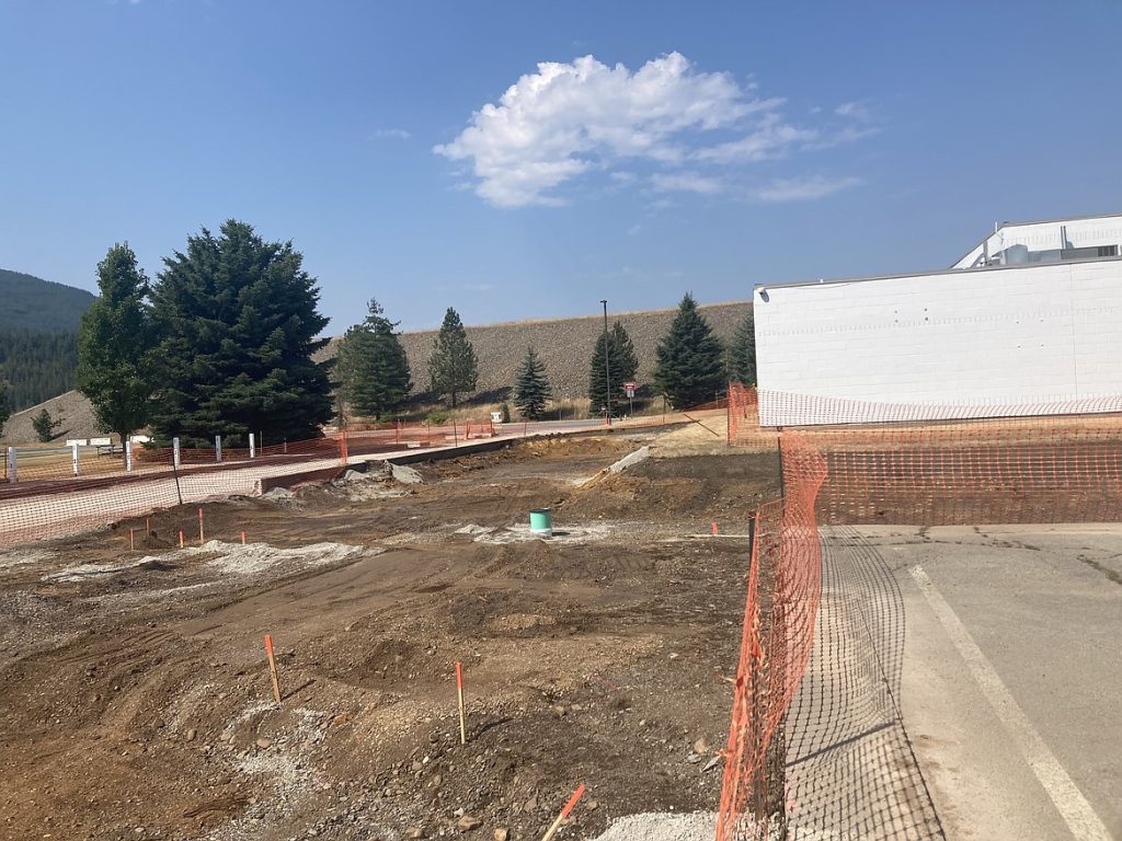
Significant progress has been made in Canyon Creek over the past several years, with multiple major remediation projects recently completed or underway. These efforts are aimed at removing contaminated material, remediating and reconstructing stream channels to provide a clean habitat. Work in Canyon Creek has been prioritized to reduce risk for residents living in close proximity to mine-impacted materials with high concentration of metals such as lead.
Cleanup began at the Star Project in 2023 and is well into its three-year construction plan. In 2025 alone, crews excavated roughly 48,000 cubic yards (CY) of waste material, which is about 4,800 dump truck loads moving 10 CY per load. To reclaim the area, approximately 47,000 CY of clean fill and vegetative cover soils will be placed back into the site. In addition, about 800 linear feet (LF) of stream will be reconstructed this year. Over the project’s duration, waste excavation will total around 150,000 CY, with nearly 2,800 LF of stream reconstruction completed.
Another major effort, the Tamarack No. 7 Project, has a cleanup scheduled from 2025 to 2026. Work in 2025 included excavation of approximately 109,000 CY of waste and the remediation of about 1,900 LF of stream channel. By project completion in 2026, it is projected that about 165,000 CY of waste will be removed and 3,100 LF of stream restored.
Earlier efforts laid important groundwork for this recent progress. From 2019 through 2022, the SVNRT Remediation Project successfully removed nearly 600,000 CY of waste material. While no direct stream remediation was conducted under this project, it moved mine waste into an appropriately constructed repository and added substantial disposal capacity for future cleanup work. The Canyon Complex Repository (CCR) now provides about 1.8 million CY of total capacity to support ongoing and upcoming cleanup activities.
Looking forward, several additional projects are planned to maintain momentum. These include work on the Flynn Mine/Black Bear Fraction, Canyon Creek Garbage Dump, Standard Mammoth Reach, Frisco Reach, Gem Complex, Lower Canyon Creek Riparian Area, and the Standard Mammoth Millsite. These sites stretch from just above the Star to the bottom of Canyon Creek.
Overall, these projects represent a significant investment in the health and resilience of Canyon Creek. The pace of work achieved over the last few years is expected to continue in the coming years. These projects strengthen Canyon Creek’s health and resilience and will continue driving measurable environmental progress in the area.
The Dirt is a series of informative articles focused on all aspects of cleanup efforts associated with the Bunker Hill Superfund Site. Our goal is to promote community awareness of contamination issues, to provide tools for protecting public health, and to keep the community informed of current and future cleanup projects. The Dirt is a group of committed and local experts from multiple agencies, including the Basin Environmental Improvement Project Commission, Panhandle Health District, Shoshone County, Silver Valley Economic Development Corporation, and the Idaho Department of Environmental Quality.
THE DIRT: The history of roads in the Silver Valley Pt. 2
As noted in part one of this series, the Silver Valley’s mining legacy runs deeper than its mountains—it is built right into the roads beneath our feet. For decades, mine waste was routinely used to build and maintain local roadways, rights-of-way, and driveways. Though this practice is long behind us, its impact can still surface today, especially for the road crews, utility workers, and contractors who continue to work in these areas.
Due to the widespread depth and distribution of contamination throughout the Bunker Hill Superfund site, complete removal of these waste materials was not economically feasible, nor logistically possible. As such, only partial removals of contaminated materials could be completed. Remediation depths vary, but most clean barriers will be either 6 or 12 inches deep, creating a clean protective layer over the remaining contaminated waste.
Roadbeds and rights-of-way are common places to run underground utilities such as fiber, gas, water, and sewer. This means most of the utility lines found within or adjacent to roadbeds throughout the Silver Valley were placed in contaminated materials. When utility, roadway, or ditch maintenance is needed, our local contractors are faced with the task of performing necessary repairs while also maintaining and restoring any remediated barriers they may encounter. This can be a big challenge, taking more time and effort than working in unremediated areas. To ensure this work is done properly and safely, contractors are encouraged to take the ICP class before working within the Superfund site.
Crews must protect remediated barriers by excavating and separating the clean barrier materials, then separating and isolating any of the deeper contaminated materials. Mishandling of contaminated materials during excavation can result in recontamination of clean areas and expose children and those near construction sites to lead and other metal contaminants. The responsible handling and disposal of these materials ensures that public health and the safety of the surrounding environment are protected. When all work is complete, contractors must ensure that the remediated barriers are restored to their original condition. While this process adds a layer of complexity to their everyday tasks, our local construction crews have mastered the methods needed to complete their work while protecting the remediation barriers that prevent accidental exposure to the contaminants that remain in our area. We thank them for their hard work and continued efforts to work safely and protect us all!
The Dirt is a series of informative articles focused on all aspects of cleanup efforts associated with the Bunker Hill Superfund Site. Our goal is to promote community awareness of contamination issues, to provide tools for protecting public health, and to keep the community informed of current and future cleanup projects. The Dirt is a group of committed and local experts from multiple agencies, including the Basin Environmental Improvement Project Commission, Panhandle Health District, Shoshone County, Silver Valley Economic Development Corporation, and the Idaho Department of Environmental Quality.
THE DIRT: The history of roads in the Silver Valley
The Silver Valley’s history is deeply rooted in mining. What started with a few mining claims quickly exploded into an industry that was created and remains the backbone of our community.
From 1886 to 1997, it is estimated that Silver Valley mines processed and concentrated approximately 130 million metric tons of metal-bearing materials, generating 109 million metric tons of mill tailings as waste byproducts. The topography of the region provided limited flat land for stockpiling and saving tailings and this became problematic for most of the mills throughout the region.
While the most convenient and common method of tailings disposal was to directly discharge them into local streams and creeks, some of these materials were used for more productive means.
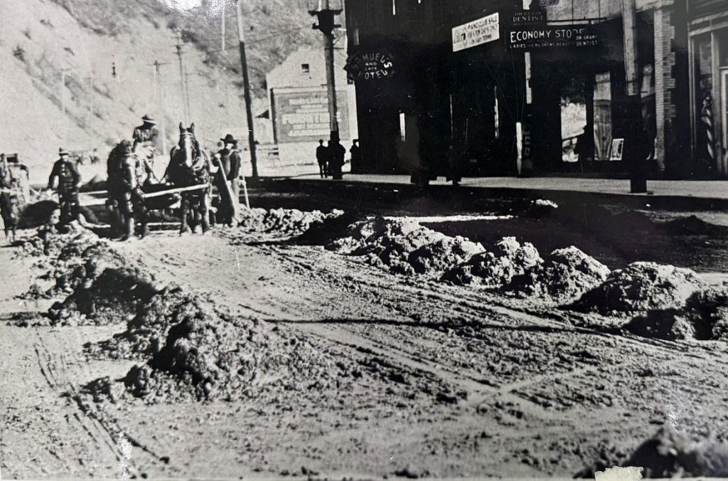
One of the most common uses was the construction of local freeways, roads, railroad ballast, and driveways. For example, during the early 1900s, the City of Wallace procured and maintained a stockpile of tailings from the Standard-Mammoth Millsite. For years, the city used horse-drawn buggies and manual labor to dump and spread tailings throughout town for new roadways and for the maintenance of pre-existing roads.
In the 1960s approximately 2.6 million tons of tailings were removed from the Bunker Hill Mine’s impoundment pond and were used to build the roadbed for Interstate 90 through the Smelterville and Kellogg areas. Approximately one million tons of tailings were also used to create the Interstate 90 roadbed near Cataldo using dredge material placed between two parallel dikes. In addition to large-scale road projects, it was also common for homeowners and contractors to use these materials on smaller projects, such as to build and improve driveways, as fill materials, or for use as a base for concrete slabs, and sidewalks.
While these materials were utilized for their convenience and practicality, they unintentionally became a major exposure source of lead, arsenic, and other metal contaminants for both humans and the environment.
The abundance of these cheap, or often free, materials naturally encouraged their widespread use. This caused contamination to be spread to areas that would not have been impacted by mine waste.
When the Bunker Hill Superfund site was established in 1983 and cleanup efforts began, road shoulders, rights of ways, ditch lines, and driveways were a major consideration for the cleanup remedy.
Since cleanup began, thousands of driveways and hundreds of miles of road shoulders have been remediated to remove surface contaminants and replaced them with clean materials, creating a protective barrier between us and the contaminated materials underneath. The next time you are out for a drive, consider what you might find below the asphalt under your tires.
The Dirt is a series of informative articles focused on all aspects of cleanup efforts associated with the Bunker Hill Superfund Site. Our goal is to promote community awareness of contamination issues, to provide tools for protecting public health, and to keep the community informed of current and future cleanup projects. The Dirt is a group of committed and local experts from multiple agencies, including the Basin Environmental Improvement Project Commission, Panhandle Health District, Shoshone County, Silver Valley Economic Development Corporation, and the Idaho Department of Environmental Quality.
THE DIRT: CIA sludge pond capped
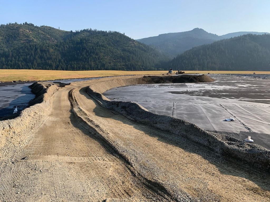
The Central Impoundment Area (CIA) has been a notable feature in the Silver Valley for nearly a century. Constructed in 1928, the CIA was designed to contain vast amounts of mine tailings and waste generated from decades of milling and smelting operations at the Bunker Hill Mining and Metallurgical Complex. Before its creation, tailings were routinely discharged directly into the South Fork of the Coeur d’Alene River, contributing to widespread contamination throughout the Basin. Over time, the CIA grew into one of the largest repositories in the region, ultimately holding an estimated 24 million cubic yards of mine waste.
The Central Treatment Plant (CTP) treats groundwater and acid mine water to remove the metals before the water enters the South Fork of the Coeur d’Alene River. The process of removing the metals creates a waste product called sludge that needs to be properly stored. The sludge pond was developed by the mine for this purpose.
In June of 2023, after 30 years of service, the historic sludge pond reached its capacity and could no longer accept waste. Placement of sludge from the CTP was shifted to the new Sludge Impoundment Area (SIA). The sludge pond was the only area on top of the CIA where a cap was not installed, due to active sludge placement from the CTP. The new SIA was installed in conjunction with upgrades to the CTP. The SIA was completed in Fall 2021 and has a design capacity of 30 years.
In the spring of 2024, the design for the cap of the sludge pond was completed. The design integrated the use of contaminated materials and material from the former sludge pond access road to fill the historic sludge pond and create a final grade that would promote drainage off the pond area once capping was complete. A large amount of effort was put into planning and communication for this project, as a portion of the former sludge pond access road will continue to be used for the ongoing operation of the CTP. In addition, access to this area was required and had to be maintained. With planning complete, the construction work began in May of 2025. The first phase of the project utilized materials onsite to build the grade of the designed cap. With the final capping completed, a liner system was installed and tied into the existing CIA cap. Clean fill material was brought in to cover the newly capped area prior to hydroseeding. Work has finished at the site, but inspections will continue into 2026 to ensure that seeding in the area is successful.
The Dirt is a series of informative articles focused on all aspects of cleanup efforts associated with the Bunker Hill Superfund Site. Our goal is to promote community awareness of contamination issues, to provide tools for protecting public health, and to keep the community informed of current and future cleanup projects. The Dirt is a group of committed and local experts from multiple agencies, including the Basin Environmental Improvement Project Commission, Panhandle Health District, Shoshone County, Silver Valley Economic Development Corporation, and the Idaho Department of Environmental Quality.
THE DIRT: 2025 Lead Health Intervention Blood Screening

Summer is the time for camping, biking, hiking, and swimming. We explore the great outdoors and, in so doing, put ourselves at risk for lead exposure. Hotter, drier, and dustier conditions also increase this risk. Anyone who recreates within the Bunker Hill Superfund Site may be exposed to lead dust. Because this is a known health risk, Panhandle Health District’s Lead Health Intervention Program (LHIP) provides a free blood lead screening event each year.
The LHIP blood lead screening provides families and individuals with the opportunity to check their summer lead exposures. This year’s “Under the Sea” screening was an underwater-themed event, providing attendees with information on lead exposure and prevention and fun giveaways. Anyone who had their blood lead level tested had the opportunity to enter a raffle for a goldfish and their bowl. Children six months to six years of age who live within the site received a $50 incentive following testing. Children in this age range are at greater risk of the effects of lead exposure. This incentive encourages testing at this critical stage in a child’s development.
Blood lead tests are conducted by first washing the testing area thoroughly with soap and water. A nail brush is used if hands are especially dirty. Testing is performed by Shoshone Medical Center’s excellent staff. A finger-poke test is performed, and results are available in a few minutes. If the results from the initial finger-prick test show an elevated blood lead level, a venous draw is then performed for confirmation. Free consultations are offered to individuals with elevated blood lead levels. During these consultations, LHIP staff determines possible sources of lead exposure, and recommendations are provided to avoid further exposure.
This year, over 350 individuals elected to be tested for summer lead exposure. If you missed your opportunity to be tested, please visit cdabasin.idaho.gov or call Panhandle Health District’s Kellogg office at 208-783-0707 to request your free blood lead test.
The Dirt is a series of informative articles focused on all aspects of cleanup efforts associated with the Bunker Hill Superfund Site. Our goal is to promote community awareness of contamination issues, to provide tools for protecting public health, and to keep the community informed of current and future cleanup projects. The Dirt is a group of committed and local experts from multiple agencies, including the Basin Environmental Improvement Project Commission, Panhandle Health District, Shoshone County, Silver Valley Economic Development Corporation, and the Idaho Department of Environmental Quality.
THE DIRT: Stormwater management in the Silver Valley
The Silver Valley has long been vulnerable to flooding during spring runoff, and one major disaster made clear how these events can threaten not only public safety but also the progress of environmental cleanup. The flooding event at Milo Creek in 1997 was especially significant, it not only caused widespread damage but also re-contaminated several properties that had already undergone remediation. In response, Milo Creek became the focus of a collaborative effort that led to major stormwater infrastructure upgrades. These upgrades were designed not just to mitigate flooding, but also to protect the integrity of past and future remediation efforts.
Following the improvements in Milo Creek, stormwater systems were enhanced throughout the Silver Valley, particularly in the large gulches that can carry massive volumes of runoff during major flood events. Most of these improvements focused on capturing stormwater and piping it directly into the South Fork of the Coeur d’Alene River to reduce the risk of localized flooding and erosion.
While redirecting stormwater away from flood-prone areas is beneficial, directly discharging it into the river raises serious concerns for water quality. As stormwater flows over roads, rooftops, parking lots, and other hard surfaces, it picks up a variety of pollutants—such as sediment, oil, grease, fertilizers, bacteria, and excess nutrients. When this untreated runoff enters the South Fork, it can degrade water quality, harm aquatic life, and contribute to nutrient loading. This nutrient pollution, especially phosphorus, can lead to algal blooms and low oxygen levels that damage ecosystems and impact water bodies all the way downstream to Coeur d’Alene Lake.
Recognizing the urgency of this issue, Governor Brad Little’s Leading Idaho Initiative has prioritized reducing nutrient loading in the Coeur d’Alene Lake watershed. Under this initiative, state funding has been allocated to support Kellogg’s stormwater improvement projects that address phosphorus and other contaminants found in runoff.
So far, three phases of stormwater projects have been completed or are underway. Each project is aimed at reducing the impact of stormwater through filtration and infiltration techniques that remove pollutants before they reach the river. Pilot projects have tested innovative approaches for slowing runoff and allowing it to soak into the ground. Treatment systems have been installed to capture and remove debris, sediment, and oil from the water. Infiltration swales throughout the city are also helping to reduce the volume of water that would otherwise flow directly into the river by allowing it to naturally infiltrate into the soil.
Once fully implemented, these efforts will treat approximately 75% of the stormwater in Kellogg. These projects represent a significant investment in both environmental protection and community resilience, helping ensure that the Silver Valley’s recovery from past contamination is protected for generations to come.
The Dirt is a series of informative articles focused on all aspects of cleanup efforts associated with the Bunker Hill Superfund Site. Our goal is to promote community awareness of contamination issues, to provide tools for protecting public health, and to keep the community informed of current and future cleanup projects. The Dirt is a group of committed and local experts from multiple agencies including the Basin Environmental Improvement Project Commission, Panhandle Health District, Shoshone County, Silver Valley Economic Development Corporation, and the Idaho Department of Environmental Quality.
THE DIRT: Join the annual Bunker Hill Superfund Site tour
The Basin Environmental Improvement Project Commission (BEIPC) invites the public to attend its annual Bunker Hill Superfund Site Cleanup Tour on Wednesday, Aug. 27. The event offers a rare, firsthand look at environmental remediation and restoration efforts in the Silver Valley, one of the nation’s most significant cleanup initiatives.
The day begins at 9 a.m. with BEIPC’s quarterly meeting at the Panhandle Health District office, 35 Wildcat Way in Kellogg. The meeting will include updates on ongoing projects, including Coeur d’Alene Lake shoreline sampling and the proposed location for a Lower Basin Waste Consolidation Area. The meeting will adjourn at 10:40 a.m., followed by a guided field tour.
The tour starts at 10:50 a.m. at Gene Day Park in Osburn, where attendees will hear from David Van de Riet of Idaho Fish and Game and Rebecca Stevens of the Coeur d’Alene Tribe about recent restoration efforts. Participants are encouraged to bring a sack lunch and water.
Following lunch, the tour will continue to the East Fork Ninemile Basin. Representatives from the Environmental Protection Agency and the Coeur d’Alene Work Trust will provide updates on completed priority cleanup work in the area. The watershed is a key focus due to its legacy of mining-related heavy metal pollution. Stops will include the East Fork Ninemile Waste Consolidation Area, the Interstate Mill Site and the Dayrock Complex.
After a brief stop in Wallace, the final leg of the tour will be at the Page Repository, where the Idaho Department of Environmental Quality will lead a tour of ongoing waste management activities. The event will conclude in Kellogg around 3:30 p.m.
This tour is a unique opportunity for community members, local leaders and stakeholders to engage with project staff, observe collaborative cleanup efforts and gain insight into the work still ahead.
Registration is required and space is limited. To reserve a seat, contact Gail Yost, assistant to the BEIPC executive director, at gail.yost@deq.idaho.gov or 208-783-2548. For updates and the full meeting agenda, visit www.basincommission.com.
The Dirt is a series of informative articles focused on all aspects of cleanup efforts associated with the Bunker Hill Superfund Site. Our goal is to promote community awareness of contamination issues, to provide tools for protecting public health, and to keep the community informed of current and future cleanup projects. The Dirt is a group of committed and local experts from multiple agencies including the Basin Environmental Improvement Project Commission, Panhandle Health District, Shoshone County, Silver Valley Economic Development Corporation, and the Idaho Department of Environmental Quality.
THE DIRT: EPA seeks public input for 5-Year Review
The U.S. Environmental Protection Agency started its sixth Five-Year Review of the Bunker Hill Superfund site last month. The purpose of a Five-Year Review is to evaluate the existing remedy and determine if it continues to protect people’s health and the environment. EPA’s evaluation of the remedy, along with its findings and conclusions, will be included in this report. Any deficiencies found in the remedy will be noted along with potential ways to address them.
The first Five-Year Review was completed in June 2000 following the start of the Superfund cleanup actions. This process repeats every five years as required by the Comprehensive Environmental Response, Compensation, and Liability Act.
The Bunker Hill Superfund site was contaminated by historic mine waste disposal practices and smelting activities, which left harmful levels of metals such as lead, arsenic, cadmium, and zinc. These metals are dangerous to both humans and wildlife. EPA’s Five-Year Reviews help monitor the impact of cleanup activities and determine whether any changes are needed.
EPA is inviting the community to participate in the current review. Any individual who lives, works, recreates or has an interest in this area is invited to share their thoughts and ideas about the site. While collecting community input for Five-Year Reviews is not required by law, it is an EPA best practice and helps the agency understand local concerns.
Interested participants should send feedback via email to EPA Community Involvement Coordinator Rafi Ronquillo at ronquillo.rafi@epa.gov. The deadline for feedback is Aug. 31. The current Five-Year Review is expected to be finished in September 2026 and published the following month.
Past Five-Year Reviews can be found on EPA’s Bunker Hill Superfund site profile webpage: https://www.epa.gov/superfund/bunker-hill. This page provides access to documentation related to the site. You can also sign up for the EPA’s e-mail list to receive any future site-related updates.
The Dirt is a series of informative articles focused on all aspects of cleanup efforts associated with the Bunker Hill Superfund Site. Our goal is to promote community awareness of contamination issues, to provide tools for protecting public health, and to keep the community informed of current and future cleanup projects. The Dirt is a group of committed and local experts from multiple agencies, including the Basin Environmental Improvement Project Commission, Panhandle Health District, Shoshone County, Silver Valley Economic Development Corporation, and the Idaho Department of Environmental Quality.
Related Articles