Author: Emily Hasz
THE DIRT: Understanding Permits for Working Near Water in the Coeur d’Alene Basin
Working near water in the Coeur d’Alene Basin often requires obtaining one or more permits, particularly when wetlands are involved. These permits ensure that restoration, construction or development activities are carried out responsibly to protect aquatic ecosystems, water quality and public resources. This article gives a summary of key permits commonly required, with a focus on activities affecting wetlands.
Wetland-related activities: Section 404 and 401 Permits
A critical permit for projects impacting wetlands, or any Waters of the United States, is the Section 404 Permit, administered by the U.S. Army Corps of Engineers (ACOE). This permit is required when dredged or fill material is discharged into rivers, lakes, streams or wetlands. Wetlands are considered protected due to their essential roles in water filtration, flood control and habitat provision.
A Section 404 Permit typically includes conditions from a 401 Water Quality Certification, issued by the Idaho Department of Environmental Quality (DEQ), Coeur d’Alene Tribe or EPA, depending on the project’s location. This certification ensures that the proposed activity complies with state or tribal water quality standards.
Application for these permits is streamlined through a Joint Application Form (between Idaho Department of Lands (IDL), Idaho Department of Water Resources (IDWR), and ACOE), which covers multiple regulatory requirements. Fees vary. General (Nationwide) permits are often free, while individual permits may cost $10–$100.
Other permits for working near water
· Idaho Stream Channel Alteration Permit: Required for any activity that alters the shape, direction, or flow of a stream. This applies to material removal or placement within the high-water mark. Issued by the Idaho Department of Water Resources (IDWR), the permit costs $20.
· Encroachment Permits: These are necessary for structures such as docks, pilings and bank stabilization along navigable waters, including Lake Coeur d’Alene and its rivers. Issued by the IDL, IDWR or the Coeur d’Alene Tribe (for projects within reservation boundaries including dredge and/or fill), these permits may also be obtained through the Joint Application Form between IDL, IDWR and ACOE.
· Floodplain Development Permits: In areas like Shoshone and Kootenai counties, work in designated floodplains requires a local permit to ensure compatibility with flood management standards. FEMA No-Rise Certifications may be required for any project in a floodway and must be reviewed to determine if the project will increase flood heights. An engineering analysis must be conducted before a permit can be issued. The community’s permit file must have a record of the results of this analysis, which can be in the form of a No-Rise Certification. This No-Rise Certification must be supported by technical data and signed by a registered professional engineer. The supporting technical data should be based on the standard step-backwater computer model used to develop the 100-year floodway shown on the Flood Insurance Rate Map (FIRM) or Flood Boundary and Floodway Map (FBFM).
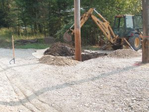
· Site Disturbance Permits: Counties such as Kootenai and Benewah may require these for grading, excavation or drainage work to protect against erosion and sedimentation. Shoshone County also requires Site Disturbance permits for waterfront and upland disturbance projects, which are typically considered high-risk and require a professional design plan. For areas within the Bunker Hill Superfund Site, an Institutional Controls Permit is also required. These permits are free of charge.
· Construction General Permit: Required for projects disturbing over 1 acre of land and discharging stormwater to U.S. waters. Managed by EPA and DEQ, it involves preparing a Stormwater Pollution Prevention Plan (SWPPP) and submitting a Notice of Intent. SWPPP’s must be displayed on the project site and visible for inspection throughout the life of the project.
· Water Rights Permits: Required for temporary or permanent diversion or impoundment of surface or groundwater. Managed by IDWR, these permits ensure legal use and sustainable water allocation. This permit is required for pulling water from area waterbodies for irrigation and drilling wells for domestic water use.
These permits are not just bureaucratic requirements; they play a crucial role in protecting water resources, especially in sensitive areas like wetlands. Applicants are encouraged to coordinate with the appropriate agencies early in project planning to ensure compliance and avoid costly delays, fines or other penalties.
THE DIRT: Waterfront properties
Idaho waters, including rivers, lakes, and streams, are designated as state property, which is meant to be enjoyed by all and is therefore protected under state and federal regulations, including the Clean Water Act. Owning, leasing, and enjoying waterfront property is a special privilege in North Idaho, but with this privilege also comes key responsibilities. Protecting your property is important, but protecting the water itself is equally important. Construction activities in and around water bodies require permits. These permits ensure construction projects or alterations are completed in a manner that will protect water quality, the environment, and aquatic species such as fish and their spawning habitats. If work is performed without the necessary permits, it can result in profound consequences, including costly fines and extremely expensive restoration work. Violations are taken very seriously, and in recent years, several local landowners have learned this hard lesson. Each individual landowner was fined thousands of dollars for failing to obtain permits and violating sections of the Clean Water Act. In addition to fines, each property owner also had to perform expensive restoration work that required hiring environmental engineers. When working around water bodies, it is in your best interest to follow all permitting procedures and requirements.
Protecting water quality is important everywhere, but has even more importance when working along water bodies within the Bunker Hill Superfund Site. Sediments found in and along most local waterways contain hazardous levels of heavy metals, including lead and arsenic. Introducing contaminated sediments into waterways when performing construction activities can be even more damaging to the environment and poses a threat to wildlife and humans. Contaminated sediments from historic mining practices have accumulated along area banks and shores for over one hundred years, altering the nature of our banks, shores, and waterways. These sediments are highly erodible and make riverbanks and lake edges much less stable. These issues often lead to owners performing erosion control and bank stabilization projects to protect their land. Before beginning any of these types of projects, make sure to contact the correct agencies. The health and beauty of our waterways depend on us all doing our part.
When it comes to protecting North Idaho’s water resources, awareness and responsibility go hand in hand, especially in areas like the Bunker Hill Superfund Site, where risks are elevated. Understanding the importance of permits is the first step. But what exactly are the permits you might need, and how do they apply when working near rivers, lakes, or wetlands?
To dive deeper into the specific permits required—particularly when wetlands are involved—read our next article, which will discuss working permits for construction sites near water inside the Coeur d’Alene Basin.
The Dirt is a series of informative articles focused on all aspects of cleanup efforts associated with the Bunker Hill Superfund Site. Our goal is to promote community awareness of contamination issues, to provide tools for protecting public health, and to keep the community informed of current and future cleanup projects. The Dirt is a group of committed and local experts from multiple agencies, including the Basin Environmental Improvement Project Commission, Panhandle Health District, Shoshone County, Silver Valley Economic Development Corporation, and the Idaho Department of Environmental Quality.
THE DIRT: 2025 Construction Season
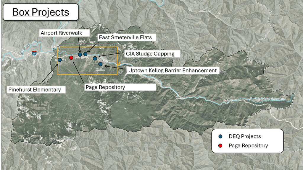
Summer arrived early in the Silver Valley this year. The trees have already bloomed, and the snow has melted off the Alhambra Slide. Flowers have been planted, and preparation for summer vacation has begun. Summer also marks the beginning of the construction season, and much is planned within the Bunker Hill Superfund site. The Idaho Department of Environmental Quality (DEQ), through funding provided by the EPA, has several projects within the Box, the 21-square-mile area surrounding the historic smelter area, to remediate and upgrade existing barriers to protect public health.
If you or your children attended or currently attend Pinehurst Elementary School, you’re probably aware of its dreaded paved playground that ices over each winter, leading to numerous injuries and a few broken bones. Due to its age and current drainage conditions, the asphalt has begun to deteriorate, increasing the potential for underlying contamination to come to the surface. This project involves removing existing asphalt and concrete barriers and existing playground surface coverings. Clean surface and subsurface materials, asphalt, concrete, turf and flexi-pave will then be used as new barriers, covering up contaminated soil across the entire project area and creating a beautiful and safe new playground
For the past 30 years, a large sludge pond on top of the Central Impoundment Area (CIA) has been used to store sludge waste produced during the treatment of contaminated mine waters at the Central Treatment Plant (CTP) in Kellogg. The pond reached capacity in June of 2023 and has been replaced by three new, lined sludge impoundments that were constructed as part of the recent CTP upgrades. The old sludge pond area will be capped with a cover system and clean materials that will tie into the existing CIA cap and meet the same performance standards as the existing cover on the CIA.
The Airport Riverwalk is a system of walking trails in Smelterville, primarily north of the airport. Last year, DEQ made improvements to the trail systems by adding additional clean gravel to help maintain the remediated barriers throughout the site. This year, DEQ will install a concrete pad just west of the parking lot area for a shade structure that is being supplied by the Kootenai Realtor’s Association. This new shaded area will provide a clean spot for trail users to take a break or have a picnic.
Also in Smelterville, just east of the old drive-in theater, additional work will be taking place. Last fall, Phase I of the East Smelterville Flats project was completed with the installation of fencing and clean gravel access areas. Phase II will begin this summer, with the installation of a new clean 12-inch deep soil cap and overlying vegetative barrier. In addition, concrete pads will be placed throughout the site for the future installation of shade structures and picnic tables. Work is anticipated to be completed this fall.
The Uptown Kellogg Barrier Enhancement project is located on the south side of Kellogg, locally known as Uptown Kellogg. This project targets the blocks between McKinley Avenue and the intersection of Upper Third Street and South Division Street. The sidewalks in this area and two other sections of the city were previously evaluated for signs of deterioration and exposed sub-base materials. This project will replace the old sidewalks with new, durable concrete barriers to protect the public from exposure to heavy metals contained in the underlying contaminated soils. It will also protect against recontamination of adjacent clean barriers and will eliminate the spread of contaminated dust and tracking of contaminated material. This project also protects surface water quality by preventing contaminated sediments from washing into the city’s stormwater system and into the South Fork of the Coeur d’Alene River.
• • •
The Dirt is a series of informative articles focused on all aspects of cleanup efforts associated with the Bunker Hill Superfund Site. Our goal is to promote community awareness of contamination issues, to provide tools for protecting public health, and to keep the community informed of current and future cleanup projects. The Dirt is a group of committed and local experts from multiple agencies, including the Basin Environmental Improvement Project Commission, Panhandle Health District, Shoshone County, Silver Valley Economic Development Corporation, and the Idaho Department of Environmental Quality.
THE DIRT: Recreate safely in the Bunker Hill Superfund Site
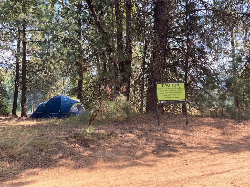
If you plan to explore the great outdoors this summer, it is important to learn more about the risks of lead and metals exposures within the Bunker Hill Superfund Site. Beginning in the late 1800s, mining shaped the lives of those living in the Silver Valley. This legacy of mining resulted in contaminants on shorelines, floodplain deposits, hillsides, and at historic mine and mill sites. You may encounter exposure to contaminants at many popular areas for hiking, dirt bike and ATV riding, fishing, swimming, boating, and camping. During recreational activities, contaminated dust can accumulate on shoes, clothing, and equipment. This dust can be transported home with you, resulting in additional lead exposure once you return home.
During outdoor recreational activities, contaminated dust can enter your body through your mouth and nose while eating or breathing. Lead accumulates in your body and has been found to cause numerous health effects in children and adults. Fortunately, by following a few simple recommendations, you can reduce your family’s exposures to contaminated dirt and dust.
During any outdoor activity, bring clean water to drink and wash your hands. Recreating, swimming, camping, and picnicking in grassy areas is always recommended to limit contact with contaminated dirt, dust, and sand. Follow all fish consumption advisories by visiting: fishadvisory.dhw.idaho.gov. Avoid recreating in or near historic mine and mill sites.
Remove shoes and dirty clothing before entering your camper or tent to avoid tracking dust inside. Keep all surfaces dust free, especially those used to prepare food or eat. Remove dust and dirt from all recreational equipment, swimming towels, and clothing before you go home. If a washing station is provided where you recreate, use it to clean your equipment. When you return home, wash your pets and equipment to remove any dust and dirt that remains. All clothing should be washed separately from regular household laundry to avoid cross contamination.
To learn more about lead exposures and the resources available to keep your family safe, please visit our new website: cdabasin.idaho.gov or contact Panhandle Health District at 208-783-0707.
The Dirt is a series of informative articles focused on all aspects of cleanup efforts associated with the Bunker Hill Superfund Site. Our goal is to promote community awareness of contamination issues, to provide tools for protecting public health, and to keep the community informed of current and future cleanup projects. The Dirt is a group of committed and local experts from multiple agencies including the Basin Environmental Improvement Project Commission, Panhandle Health District, Shoshone County, Silver Valley Economic Development Corporation, and the Idaho Department of Environmental Quality.
THE DIRT: Work begins throughout the CDA Basin
With our pleasant early spring weather, construction season is well underway in the Silver Valley. The Coeur d’Alene Trust (CDA Trust), under the direction of the Environmental Protection Agency, has several projects taking place in the Coeur d’Alene Basin this season. In the Upper and Lower Basins, cleanup work will continue to address contamination, reduce exposure to people and wildlife, and improve water quality.
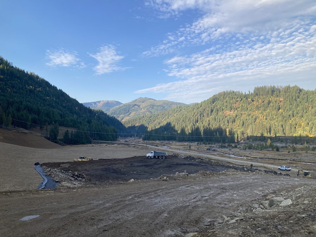
All Ninemile Creek basin priority cleanups were completed in 2024. Mine waste from the completed cleanup projects was deposited in the East Fork Ninemile Waste Consolidation Area (WCA). Construction of the final cover system for the WCA will begin in 2025 and will be complete in 2026.
Cleanup work continues at the Star Complex near the community of Burke and at the Tamarack No. 7 site near the community of Black Bear. Work will include excavating and hauling mine waste materials to the Canyon Complex Repository/WCA. Following mine waste removals, clean backfill materials will be placed at the sites, disturbed areas will be revegetated, and portions of Canyon Creek will be reconstructed. Work at the Star and Tamarack No. 7 sites is expected to be complete in the fall of 2026.
Work will also be taking place in the Pine Creek basin at the Douglas Complex, located approximately six miles south of Pinehurst along East Fork Pine Creek Road. Cleanup will include re-grading and capping of mine wastes, and placement of clean backfill materials. Cleanup is anticipated to be complete in the fall of 2025.
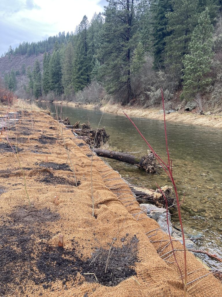
In the Lower Basin, work continues at Gray’s Meadow to finish a 700-acre wetland remediation and restoration project. The remaining soil excavation, construction of habitat features, and revegetation will be completed by fall of 2025.
Beyond these cleanup projects, the Lower Burke Canyon Repository, Big Creek Repository, and East Mission Flats Repository will be operated to accept contaminated materials from a variety of projects.
We look forward to a safe and successful 2025 construction season. CDA Trust projects support local businesses, suppliers, and contractors.
The Dirt is a series of informative articles focused on all aspects of cleanup efforts associated with the Bunker Hill Superfund Site. Our goal is to promote community awareness of contamination issues, to provide tools for protecting public health, and to keep the community informed of current and future cleanup projects. The Dirt is a group of committed and local experts from multiple agencies including the Basin Environmental Improvement Project Commission, Panhandle Health District, Shoshone County, Silver Valley Economic Development Corporation, and the Idaho Department of Environmental Quality.
THE DIRT: Recreating Safely in the Bunker Hill Superfund Site

The Bunker Hill Superfund Site in North Idaho’s Coeur d’Alene River (CDA) Basin has a history of mining-related contamination. While the region offers hiking, biking, fishing, and ATV/side by side/Motorcycle riding, these activities should be approached with caution due to lead and other heavy metals in the soil and water. To promote safe recreation, the Recreation Sites Program was established in 2016 to assess and manage health risks.
Developed in collaboration with agencies like the Environmental Protection Agency (EPA), Idaho Department of Environmental Quality (DEQ), and Panhandle Health District (PHD), this program provides strategies for mitigating exposure risks. A key initiative is the Basin Recreational Sites Strategy, which outlines methods for identifying and managing contaminated areas, conducting outreach, and gathering public input. A similar strategy is being developed for the Box region, with finalization expected in 2025.
Addressing contamination at recreation sites is challenging due to recurring recontamination from flooding events. Unlike standard cleanups that replace contaminated soil, many recreation sites require ongoing management. Trails, dispersed camping sites, and ATV areas present additional cleanup difficulties due to remote and rugged terrain, requiring tailored approaches.
Public education is vital for safe recreation. The outreach efforts inform visitors about health risks and safe practices. Individuals are encouraged to wash their hands before eating, avoiding soil contact, and follow posted guidelines to avoid recreational exposure to lead and other heavy metals. These efforts continue to expand.
In 2025, the Recreation Sites Program team will meet biannually to evaluate progress. The CDA Trust will monitor completed projects, update signage, and assess cleanup options for recreation areas in the CDA Basin. In the Box, DEQ and PHD will update signage and improve access controls at key recreation sites.
To engage the community, a Citizens Coordinating Council (CCC) Educational Brown Bag Community Meeting is planned for May 21st from noon to 1:00 PM at the Fernan Forest Service Building (2502 E Sherman Ave, Coeur d’Alene, ID 83814). The meeting is open to the public and will also be available virtually via Microsoft Teams. The session will cover how to safely recreate in the Bunker Hill Superfund Site, with presentations from EPA and PHD. Attendees joining in person should bring their own lunch, and a special election for a new CCC Chair will also take place. This is a great opportunity for residents to learn more, ask questions, and become involved.
By balancing remediation with public awareness, the Recreation Sites Program ensures residents and visitors can enjoy the CDA Basin safely while reducing health risks from legacy contamination.
The Dirt is a series of informative articles focused on all aspects of cleanup efforts associated with the Bunker Hill Superfund Site. Our goal is to promote community awareness of contamination issues, to provide tools for protecting public health, and to keep the community informed of current and future cleanup projects. The Dirt is a group of committed and local experts from multiple agencies including the Basin Environmental Improvement Project Commission, Panhandle Health District, Shoshone County, Silver Valley Economic Development Corporation, and the Idaho Department of Environmental Quality.
THE DIRT: Fish consumption advisory for the Cd’A Basin
North Idaho offers some of the best fishing opportunities in the region, with Lake Coeur d’Alene and surrounding waters providing a rich habitat for a variety of fish species. Unfortunately, like many water bodies across the country, some fish species in this area have been found to contain elevated levels of mercury. To ensure safe and enjoyable fishing experiences, health officials have issued guidelines to help anglers monitor their fish consumption.
Studies conducted by the Idaho Department of Health and Welfare (DHW), the Department of Environmental Quality (DEQ), Panhandle Health District, Fish and Game and the Coeur d’Alene Tribe have detected elevated mercury levels in species such as northern pike, bass and kokanee. Mercury is a naturally occurring element that can also be introduced through industrial activity. It is a neurotoxin that can impact brain development and nervous system function, particularly in pregnant women and young children. Mercury is the main contaminant of concern driving fish consumption meal limit recommendations.
To minimize exposure to these contaminants, health officials recommend limiting your intake to no more than the following per month:
• 2-5 servings of northern pike
• 3-11 servings of panfish
• 6-20 servings of kokanee
• 1-4 servings of bass
Serving size and quantity varies depending upon your inclusion in the general adult population, if you are pregnant or if you are a child. The location where a fish was caught can also affect the amount of mercury accumulated within a fish. For more specific recommendations please visit: http://fishadvisory.dhw.idaho.gov.
The advisory recommends eating younger fish and those lower in the food chain, such as trout and kokanee, because they are generally less contaminated. Fat should be trimmed and skin and organs removed before cooking fish to reduce the likelihood of contaminants. Cooking methods such as grilling or broiling do not reduce mercury content, making it essential to follow these guidelines when consuming local fish.
Beyond mercury, legacy contamination from historical mining activities has introduced heavy metals like lead, arsenic and cadmium into the Coeur d’Alene Basin. These pollutants settle in lakebed sediments and accumulate in fish, further increasing potential health risks. Levels of cadmium, arsenic and lead found in fish tissue are not expected to harm people’s health when following meal recommendations.
The DHW recognizes the health benefits of eating fish and is providing this advisory to encourage safe consumption. Fishing remains a beloved activity in North Idaho, and by staying informed, residents and visitors can continue to enjoy the sport while making health-conscious choices about fish consumption.
• • •
The Dirt is a series of informative articles focused on all aspects of cleanup efforts associated with the Bunker Hill Superfund Site. Our goal is to promote community awareness of contamination issues, to provide tools for protecting public health, and to keep the community informed of current and future cleanup projects. The Dirt is a group of committed and local experts from multiple agencies including the Basin Environmental Improvement Project Commission, Panhandle Health District, Shoshone County, Silver Valley Economic Development Corporation, and the Idaho Department of Environmental Quality.
THE DIRT: What you need to know about ICP Permits
Spring is in the air, and you know that means; it’s time to swap snow boots for sneakers and get back outside, residents of North Idaho are eager to get outside and work in their yards. Before heading out to work, are you confident you have everything you need? Sure, you have your shovel, your gloves, and your freshly applied sunscreen. But what about your permit?
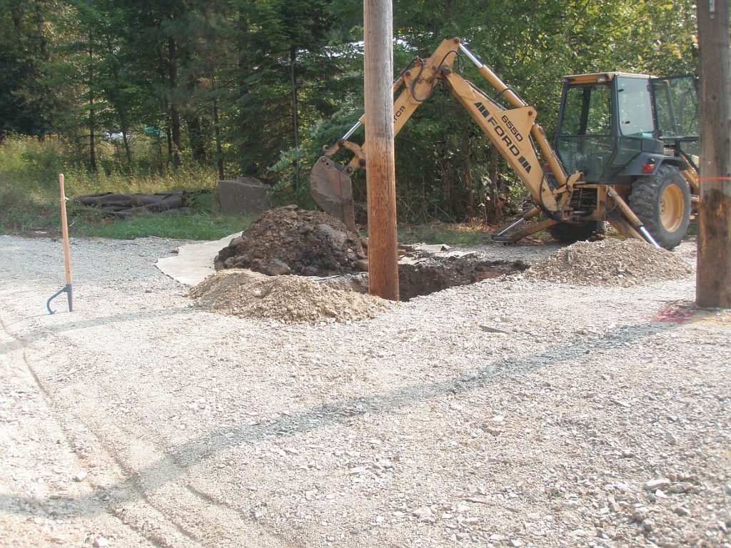
If you live within the Bunker Hill Superfund Site (BHSS) and you have projects that involve digging, grading, and/or excavation, you may also need an ICP excavation permit from Panhandle Health District.
Residents of the BHSS live in a geographic region that was impacted by lead and other heavy metals from historic mining, milling, and smelting practices. Cleanup measures taken at the BHSS are unique because contamination is so widespread and so deep in some areas that total removals could not be completed.
After the establishment of the Site in 1983, EPA collaborated closely with the community as they conducted Remedial Investigations and Feasibility Studies to determine the most effective, efficient, and logistically attainable cleanup method. After considering numerous options, it was determined that partially removing contaminated materials and replacing them with clean materials was the most feasible option available.
Soil sampling criteria were developed and remedial action levels established. After property owners provided consent, soil samples were collected from each property and cleanup decisions were made based on those sample results. To date, over 7,000 properties have undergone some form of remedial cleanup.
Not every property located within the BHSS qualified for remediation, but that does not mean these properties are completely contaminant free. And those that did qualify may have a variety of barrier types and depths. Typical barriers range in depth from six to twelve inches and consist of either gravel or topsoil.
Because only partial removals could be performed, contaminated materials can still exist beneath these barriers. Barrier fabric was often, but not always, used to mark the transition between clean barrier material and the contaminated material that remains. Dirt disturbing projects can compromise or damage clean barriers, thereby creating a health risk for individuals living near these compromised barriers, with children and pregnant women at highest risk. The Institutional Controls Program (ICP) was established under Panhandle Health District to issue permits and oversee dirt disturbance activities, and to ensure that barriers are properly maintained and reinstalled if disturbed.
Free ICP permits are required anytime a remediated barrier, or contaminated materials are disturbed, or if one cubic yard or more of soils containing contaminants must be moved. An ICP permit will provide you with sample data available for your property, records of any remediation work, and guidelines for safely completing your project. These permits also give you access to free soil disposal repositories and supplies to help you safely complete your project. Permits are a legal requirement and help protect homeowners from future legal ramifications of compromised barriers when their property is sold.
So, before you head outside and start your spring and summer projects, be sure to contact the ICP to see if you need a permit. Inquiries and permit requests can be made through our website cdabasin.idaho.gov, over the phone at (208)783-0707, or in person at 35 Wildcat Way in Kellogg.
The Dirt is a series of informative articles focused on all aspects of cleanup efforts associated with the Bunker Hill Superfund Site. Our goal is to promote community awareness of contamination issues, to provide tools for protecting public health, and to keep the community informed of current and future cleanup projects. The Dirt is a group of committed and local experts from multiple agencies including the Basin Environmental Improvement Project Commission, Panhandle Health District, Shoshone County, Silver Valley Economic Development Corporation, and the Idaho Department of Environmental Quality.
THE DIRT: EPA conducting waterfowl survey
The Environmental Protection Agency (EPA), in collaboration with wildlife management staff from State, Federal, and Tribal organizations, is conducting a study to develop tools for monitoring waterfowl health and exposure to lead contamination in the Lower Coeur d’Alene River Basin. The team includes scientists from the U.S. Fish and Wildlife Service, the Coeur d’Alene Tribe, Idaho Fish and Game, the U.S. Geological Survey, and EPA. The study aims to assess the effectiveness of remediation and restoration efforts by tracking changes with new biomonitoring tools.
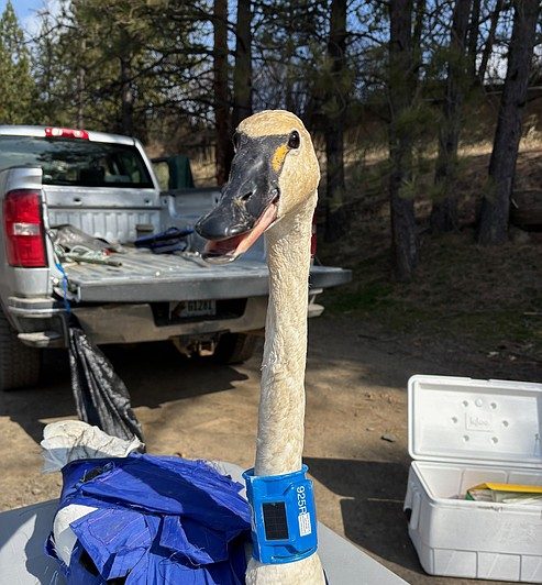
Tundra swans migrating between California and Alaska stop in the Coeur d’Alene Basin each spring. While foraging in contaminated wetlands for food buried in the sediment, they incidentally ingest toxic levels of lead from the sediment. Wood ducks, a species that nests in the Basin, are also vulnerable to lead ingestion while foraging for insects and submerged plants. Lead exposure results from ingestion of sediments contaminated by historic mine tailings that were once discharged directly into waterways by mining companies operating in the Silver Valley. This practice spread contaminants throughout the Lower Basin of the Coeur d’Alene River. Despite changes in mining practices, previously discharged toxic sediments remain accessible to waterfowl throughout most of their habitat.
The number of tundra swan deaths fluctuates annually. In 2022, 388 swans were found dead likely due to lead exposure from prolonged stays in the contaminated Basin. The swans may have been more vulnerable to exposure than in previous years due to a greater need for food after encountering limited feeding habitats in California from drought. Furthermore, feeding habitats in the Basin were also limited due to ice, forcing them to feed in areas with heightened risks for exposure to contaminated sediments. While the continental swan population remains stable, ongoing efforts aim to reduce lead exposure to improve swan health.
Field teams are collecting and testing blood and feces from trapped birds, while also monitoring exposure by placing GPS or radio collars on swans and wood ducks. Scientists will also collect and analyze samples from additional waterfowl, invertebrates, sediment, and water across wetlands, ranging from clean areas in the St. Joe River watershed to heavily contaminated sites in the Coeur d’Alene River Basin. Sampling will continue through mid-March 2025 for swans and from late March through June for wood ducks.
A key goal of the study is to develop noninvasive biomonitoring methods to measure lead exposure. Rather than relying on expensive traditional blood sample measurements which require specialized experience and extensive permitting, researchers are testing the use of fecal material and eggshells to assess aquatic waterfowl exposure to metals and track changes over time as remediation and restoration work create clean habitat in the Lower Coeur d’Alene Basin. The study may also provide information to aid in future wetland cleanup efforts, ensuring that waterfowl are attracted to clean habitats rather than toxic ones. EPA and the Restoration Partnership are already working on projects such as Gray’s Meadow, where soil cleanup and habitat restoration are underway, with completion expected by the end of 2025.
Public involvement is encouraged. If individuals encounter a dead tundra swan or a wood duck with a neck collar or satellite transmitter, they are asked to report sightings to Idaho Fish and Game at (208)-769-1414. The study findings will be made available to the public by EPA when complete.
The Dirt is a series of informative articles focused on all aspects of cleanup efforts associated with the Bunker Hill Superfund Site. Our goal is to promote community awareness of contamination issues, to provide tools for protecting public health, and to keep the community informed of current and future cleanup projects. The Dirt is a group of committed and local experts from multiple agencies including the Basin Environmental Improvement Project Commission, Panhandle Health District, Shoshone County, Silver Valley Economic Development Corporation, and the Idaho Department of Environmental Quality.
THE DIRT: Completion of Priority Cleanup Activities in the Ninemile Basin
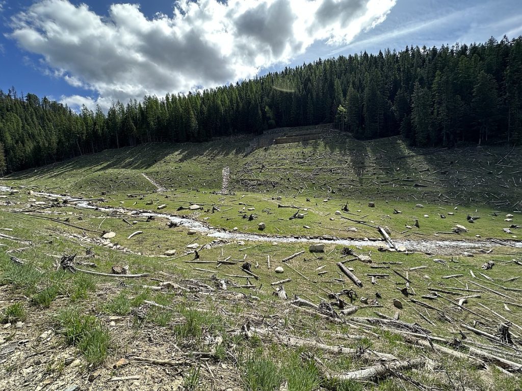
All priority cleanup activities in the East Fork Ninemile (EFNM) Basin have been successfully completed, marking a significant milestone in environmental cleanup efforts. The EFNM Waste Consolidation Area (WCA) has reached capacity, and final closure activities are now underway. As this phase concludes, monitoring efforts will continue to assess the effectiveness of the remedial actions.
The Ninemile watershed, located near Wallace, Idaho, spans approximately 12 square miles, with Ninemile Creek extending 7 miles from its confluence with the South Fork Coeur d’Alene River (SFCDR) to the EFNM Creek headwaters. This area has been significantly impacted by historical mining activities dating back to the late 1800s, which introduced elevated metal concentrations into sediments, soil, and water.
In 2012, the Interim Record of Decision Amendment (RODA) identified 36 legacy mining sites contributing to metal contamination in the Ninemile Basin. These sources included waste rock dumps, mine workings, fill areas, and jig tailings piles. Initial, limited cleanup efforts by the Coeur d’Alene Tribe and Idaho Department of Environmental Quality (DEQ) began in the 1990s, followed by remediation of the Rex No.2/Sixteen-to-One Mine between 2002 and 2007. In 2014, the Coeur d’Alene Trust launched extensive remedial actions (RAs) in line with the work outlined in the RODA. Through an adaptive management approach, the U.S. Environmental Protection Agency (EPA) collaborated with stakeholders to prioritize and implement RAs across the Upper Basin, with the Ninemile Basin designated as an initial focus area due to its significant contribution of dissolved and particulate metals to area waterbodies.
Since 2014, cleanup work in the EFNM Basin has been ongoing. These efforts included the design and development of the WCA and remediation of major sites such as the Interstate Callahan rock dumps, Success Complex, Interstate Millsite, Lower EFNM Creek, Tamarack Complex, and Dayrock Complex. In total, approximately 1,545,000 cubic yards of waste were excavated and hauled to the EFNM WCA for placement and compaction, and approximately 15,000 linear feet of stream were reconstructed. The EFNM WCA generated approximately 350,000 cubic yards of rock and 375,000 cubic yards of soil for the Ninemile Basin remedial actions. The EFNM WCA’s strategic location near contamination sources resulted in an estimated $8.5 million in transportation cost savings while minimizing traffic disruptions to local communities. By late 2024, the EFNM WCA reached capacity, and final cover design was completed. Construction of the final cover system is anticipated for completion in 2025 and 2026, signifying the culmination of key cleanup efforts.
To ensure the long-term success of these remedial actions, the Basin Environmental Monitoring Plan (BEMP) was developed in accordance with the 2002 ROD and 2012 RODA. The BEMP provides a framework for assessing the effectiveness of cleanup activities, guiding the collection, analysis, and interpretation of environmental data. In the Ninemile Basin, RA effectiveness monitoring will evaluate progress toward remediation objectives, including water quality improvements and ecological responses. Monitoring efforts, which will continue for at least five years, will determine whether performance goals have been met. If goals are achieved, monitoring will transition to a site-wide program; if not, further assessments will be conducted to identify additional recommendations for achieving long-term environmental objectives in the Ninemile Basin.
The Dirt is a series of informative articles focused on all aspects of cleanup efforts associated with the Bunker Hill Superfund Site. Our goal is to promote community awareness of contamination issues, to provide tools for protecting public health, and to keep the community informed of current and future cleanup projects. The Dirt is a group of committed and local experts from multiple agencies including the Basin Environmental Improvement Project Commission, Panhandle Health District, Shoshone County, Silver Valley Economic Development Corporation, and the Idaho Department of Environmental Quality.
Related Articles